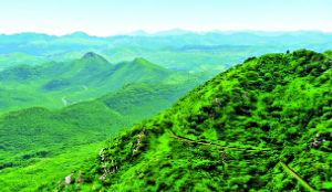
Aravalli Hills and Ranges: Myths versus facts

What is the new definition for the Aravalli Hills and Range? Not one, but two definitions are in play here. One, for the Aravalli Hills, and another for the Aravalli Range. Any landform in the Aravali districts with an elevation of 100 meters or more above the local relief (lowest encircling contour line). Includes the entire enclosed area (hill, slopes, associated features) regardless of gradient. Two or more such hills within 500 meters of proximity (measured from outermost lowest contour points). Includes intervening area via buffers and perpendicular lines, plus features like hillocks/slopes.
How is the area of the ‘protected cluster’ or the ‘range’ between two tall hills decided? There is a method to this. It’s not random. In GIS terminology, it’s often called ‘buffer intersection analysis with perpendicular offset’ or simply part of a ‘buffer and intersect workflow’.
It’s commonly used for spatial analysis to define connected or enclosed areas between features, such as in ecological corridor mapping, range delineation, buffer zones for environmental protection, or terrain modelling (eg, identifying valleys, ridges, or wildlife habitats between elevated points).
Who gave the new definition-the Government of India or the Supreme Court?
In its judgment dated November 20, 2025, the Supreme Court (SC) adopted a uniform definition of the Aravalli Hills and Ranges. Paragraph 50. Point (i). This definition was recommended by a Committee formed pursuant to the SC’s order of May 9, 2024, which consisted primarily of Government of India (GOI) officials and was chaired by the Secretary of the Ministry of Environment, Forest and Climate Change (MoEF&CC). Although the recommendation originated from this GOI-led Committee, the SC rendered it legally binding by incorporating it into the judgment. ‘We accept the recommendations made by the Committee with regard to the definition of Aravali Hills and Ranges given by MoEF&CC’.
Why was there a need for a new definition now?
The judgement primarily addresses the lack of a uniform definition of ‘Aravali Hills and Ranges’, which has led to inconsistent conservation efforts, rampant illegal mining, and ecological degradation across Delhi, Haryana, Rajasthan, and Gujarat.
The apex court aimed to resolve this by establishing a standardised definition to enable scientific, sustainable regulation of mining activities, prevent desertification (eastward spread of the Thar Desert), and protect the Aravalis’ role as a ‘green barrier’ for biodiversity, climate, and water resources.
This stems from India’s obligations under the UN Convention to Combat Desertification (UNCCD, ratified 1996) and national initiatives like the Aravali Green Wall Project. However, the legal pursuit of this definition did not begin yesterday, or in 2014, or in 2004, or even in 1994. The two critical cases emerged from two ongoing PILs — MC Mehta v Union of India (1985, focused on Haryana mining) and TN Godavarman Thirumulpad v Union of India (1995, broader forest conservation, including Rajasthan). Eventually, in May 2024, the court directed the need for a uniform definition of the Aravalli Hills and Ranges.
The committee working on the definition comprised the Secretary, MoEFCC (heading it), and secretaries of the department of forests from the Government of NCT of Delhi, Haryana, Rajasthan and Gujarat. Also included were the representatives from the Forest Survey of India (FSI), the Central Empowered Committee (CEC), and the Geological Survey of India (GSI).
On August 12, 2025, the apex court reiterated the need for a uniform definition, citing gaps and practices that had harmful effects on the range.
This is where the consultations went into a hyperdrive mode, for only Rajasthan had a formal definition on Aravalli Hills and Ranges. This opened up the ranges to illegal mining in Haryana and other regions.
Where does the definition come from?
It comes from the wonderful state of Rajasthan itself. The state’s definition comes from the 2002 committee report and Richard Murphy’s (1968) Landform Classification, identifying landforms rising 100 metres above the local relief as hills and prohibits mining on both the hill and its supporting slopes. The state of Rajasthan has been following this definition since January 9, 2006.
What else did the Supreme Court say in its November order?
The apex court has directed the MoEF&CC to prepare a Management Plan for Sustainable Mining (MPSM) through the Indian Council of Forestry Research and Education (ICFRE) for the entire Aravallis, as geologically defined between Delhi and Gujarat.
The objective of the MPSM is to identify permissible areas for mining, ecologically sensitive, conservation-critical and restoration-priority areas within the Aravali landscape where mining shall be strictly prohibited or permitted only under exceptional and scientifically justified circumstances (critical, strategic, and atomic minerals exception stands).
A cumulative analysis of environmental impact and the ecological carrying capacity of the region has also been ordered, along with detailed post-mining restoration and rehabilitation measures. Until the MPSM is finalised by the Government, no new mining leases will be granted. Upon the finalisation of the MPSM, mining would be permitted as per the MPSM only in areas where sustainable mining has been permitted. For the ongoing mining operations, strict compliance will have to be ensured as recommended by the government. Thus, they have not been halted. 1.44 lakh square kilometres of Aravallis are now under threat, aren’t they, as claimed on social media? No, the judgement doesn’t open up the entire range to mining automatically. The 90 per cent derivation is also incorrect, for it factors in the assumed number of hills below the height of a hundred metres, but the judgement comes with additional carriers. For starters, there is the 500m rule, discussed above. Two, there are several ecologically sensitive zones falling under the protected category across the states. In Rajasthan, there are 20 of them, like the Sariska Tiger Reserve, and several other wildlife sanctuaries. Gujarat and Haryana have a dozen such protected areas. Several iconic buildings and monuments, and other structures of historical importance, also fall within the range. Rajasthan alone has over a hundred such monuments, while the total count exceeds 150. Add to this the reserved and protected forests and the wetlands. You can’t mine there. Three, and most importantly, the MPSM ordered by the apex court is to be done on the lines of what was prepared for the Saranda Forest Area of Jharkhand. Therefore, for each of the 37 districts falling in the range, a separate study identifying permissible areas for mining, ecologically sensitive, conservation-critical, and restoration-priority areas is yet to be done. Therefore, the 90% assumption is technically incorrect. To say that all landforms below 100 metres are now automatically open for mining is to ignore the other technicalities within the judgement.
The writer is a Delhi-based journalist and political commentator. He runs his Substack at politypolicy.substack.com, where he writes on policy, economics, finance, and technology ; views are personal