Why should you give flights a miss? Get answers from Chandan Mitra who drove to Leh and back over the world’s highest mountain passes and verdant valleys. Photos by Shobori Ganguli
Over the mountain
Take me across the sky
Something in my vision,
Something deep inside
Where did I wander
Where d’ya think I wandered to
I’ve seen life’s magic
Astral plane I travel through
Why should anybody drive to Leh from Delhi over three days, across some of the highest, motorable mountain passes in the world, braving intense winds and snow, spending nights in perfunctory Army camps? Well, the first reason is the same as that offered by Sir Edmund Hillary on his climb to Mt Everest: Because it’s there. The second, and better, reason for opting to drive 1,100 km instead of taking a flight is that there’s no other way to see some of the most spectacular natural creations or experience the sheer magic of nature in all its unspoilt splendour. There’s a third reason too. The arduous drive is perhaps one of the last motoring adventures left in the world that can be undertaken by those who aspired to rally driving but didn’t quite make the grade. I have a private reason as well, to test drive my new Hyndai Terracan.
This is not an adventure to be undertaken by amateurs. The journey is strenuous, especially the steep climbs to Baralacha-La, Lachung-La and Tanglang-La passes, the last being the world’s third (or, is it second?) highest motorable pass at 17,582 ft. The highest incidentally is Khardung-La on the way to Siachen at 18,500 and the second highest is Changu- La (apparently) at 17,800 on the road to Pangong Tso (lake) from Leh. The road is narrow at the best of times and there’s no road at all in many instances. The snow on mountain tops melts throughout the summer, often sending cascades of crystal clear, chilly water down the slopes and onto what was once billed as a road. You need to be confident enough of tackling boulders, slush caused by waterlogging and even accumulated snow on occasion. For the rest of the time, dust swirls under the impact of high winds that sear through the desolate mountains. Often enough, the ascents and descents are extremely sharp and tiring — the Gata Loops between Sarchu and Pang Tor instance, when you climb over 4,000 ft in 21 loops. Oncoming vehicles, usually Army convoys and commercial trucks, make driving a challenging proposition, especially stopping by at Rohtang because you need to make way for them, sometimes by reversing into a slightly wider point since the road is mostly too narrow for two big vehicles to pass each other.
.jpg)
Keeping these challenges in mind, I chose the Terracan, which while being big on size, allows for great manoeuverability and pickup in such tough, go anywhere situations. The vehicle is agile, has a better road grip and high ground clearance, perfect for climbing such hilly terrain. I must mention how its 16-inch alloy wheels allowed me to negotiate muddy and slippery stretches with confidence.
The journey began somewhat unexcitingly at once-charming Manali. I heartily recommend the drive to Manali. The hill road is wide enough not to cause too much tension to city drivers and the sight of the frothing Beas is therapeutic.
Suitably rested, we left Manali 36 hours after we arrived, having tanked up our vehicle and filled a big jerrycan by way of insurance. There are no fuel stations beyond Keylong (just over 100 km from Manali) till Leh town, a distance of nearly 400 km. In the event, I didn’t need to use the reserve diesel as theTerracan’s tank is big enough and its fuel economy amazing.
But everybody is advised to carry extra fuel on this journey to guard against contingency, especially because the fuel tends to burn faster in Ladakh’s rarified atmosphere, lowering the mileage you normally get in the plains. One tip here for aspiring adventurers — we carried a 45-litre plastic can, which is not advisable. Experienced Army drivers told us we ought to have bought smaller metal cans instead for they seal effectively and are easier when it comes to pouring fuel into the car’s tank.
.jpg)
We had hoped to encounter our first snow at Rohtang Pass (12,300 ft), but it hadn’t snowed adequately last season. That didn’t deter zillions of plains tourists from donning hired snowsuits and gloves to play with patches of snow that had turned brown from the dust and grime kicked up by the thousands of vehicles that gather at the peak every day. The best part about crossing Rohtang is that immediately thereafter, the madding crowd vanishes as if in thin air. Suddenly yours is the only car as far as the eye can see and you are in the wrap of solitude. Barring the occasional truck or Army vehicle that passes by giving you a quizzical look (because your four-wheeler doesn’t look sarkari), you are virtually alone on the winding road. We carried hot water, coffee sachets and enough snacks not to worry about lunch, consuming them at occasional stops on the roadside to admire the growing barrenness of the sharply rising mountains. There’s enough stowage within the comfortable cabin of the Terracan to sip and munch on the move. Driving never seems tedious with this SUV. You seldom feel stiff as the tilt adjustable steering gives you a perfect posture. For copassengers, there’s an added luxury. They can stretch themselves out on the back seats. Being a good driver, Shobori too decided to take the wheel while I eased myself out.
Soon enough, the road descends into the valley of the gushing waters of the Chandra. At Tandi, some 10 km before Keylong, the Bhaga river joins it. From Tandi, it becomes the Chandrabhaga or Chenub. A quick recap: You cross the Shatadru (or Sutlej) as you leave Ropar and drive along the Bipasha (Beas) on the road to Manali. That leaves just Jhelum and Sindhu (Indus) of the Five Rivers of Punjab. We would encounter both in a while.
Keylong has grown hugely since I visited it last. The Himachal Pradesh Tourism bungalow occupies the best spot on the watershed of a hill overlooking the town and valley of the Bhaga. On the way to the Army camp at Patsio, we drove through Jispa, about 30 km upstream, the preferred night halt of most trekkers and bikers. Jispa is the last point on the road to Leh where you can get comfortable accommodation. Hereafter, it’s only Army camps or tents. Patsio turned out to be much farther from Keylong than I had estimated. On the way we crossed Darcha, a hub of trucks and buses. Darcha offers spectacular views of two mountain streams merging in a sprawling valley.
.jpg)
Since Keylong and Jispa are quite accessible, I would recommend a visit to Darcha even for those not intending to undertake a journey all the way to Leh. You get quite close to the topography of Ladakh here itself. After traversing some rather challenging dust tracks, we reached the Army camp at Patsio (13,200 ft) around 7 pm. Set on a windswept valley, shielded by snow-covered peaks on all sides, Patsio seemed like a mirage from a distance. We were hospitably received by the Army, promptly offered a cup of hot tea and led to our cabin thereafter. Patsio is a well-organised camp, upgraded after the 1999 Kargil War. Although a drink helps combat the chilly winds better, one has to be careful with the amount consumed in these parts, at least till fully acclimatised. Oxygen being relatively inadequate, consumption of alcohol tends to burn up this life-giving gas in the blood faster, causing headaches and giddiness. Do not exceed two pegs. For smokers like me, it’s double jeopardy. I did take it easy at Patsio for one tends to get breathless just walking 100 metres. The advantage of driving into the heights of Ladakh is that the body adjusts gradually and the mountain sickness many people experience flying into Leh from the plains, doesn’t happen. Still, take precaution. We even carried two small oxygen cylinders (readily available at chemists) just in case.
The real thrill of mountain driving begins after Patsio as one approaches the quaintly named pass of Zingzing Bar on the way to windswept Baralacha-La. Am glad I chose the Terracan for this trip because its height-adjustable driver seat gives you the desired, elevation to look further while negotiating curved roads. No matter how narrow the curve might be, the Terracan’s strong body and wide side impact beams give you enough cushion for any eventuality.
.jpg)
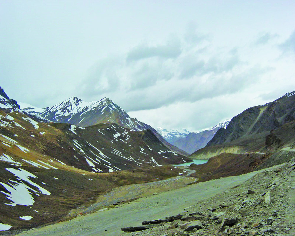
One of the most spectacular sights we encountered was a deep, still lake formed in the cup of the pass. The eerie sound of silence, the gentle ripples on the aquamarine lake’s surface, the occasional flutter of a lonely sparrow’s wings and the sheer barrenness of the landscape, all add up to a fascinating experience.
There are many such nameless water bodies strewn across Ladakh, caused by glacial activity in the Ice Age, that get filled up every summer by melting snow. In many places, you come across mountain streams that are frozen in parts; sometimes, water flows from below a chadar of ice that’s yet to melt. For lovers of natural beauty, these unusual sights are bound to remain etched forever in memory.
Ladakh is dry, sandy, rugged, hopelessly desolate, green patches are few and far between and you may not encounter a living being for what could seem an eternity, Barren it is, but monotonous certainly not. For instance, as we winded our way down from the snowy wastes of Baralacha-La, the road ushered us into the magnificent Sarchu plains. Here it’s flat for some 20-odd km, the evenness interspersed only with infrequent rocky outcrops, dry beds of once- upon-a-time mountain streams, coarse grass and wild horses grazing in the distance. A river cuts through the plains and over millennia has carved a deep crevasse for itself. Wind action along the gorge has caused some spectacular natural sculptures. From a distance, they look like remnants of a gigantic palace, complete with pillars, arches and living quarters.
As we drove along the road to Pang, we decided to take another break and drive over a boulder-strewn patch to get a closer look at the river. When you are on the Terracan, such wayward rides can never be bumpy because it has excellent shock absorbers.
We did notice a shack on the way, but it looked too dilapidated to be official accommodation. We were wrong. As we neared it, two armed jawans stepped out, enquired why we had deviated from the road and, satisfied, politely waved us on. We parked some 200 metres away and decided to make ourselves some coffee. To our surprise, we soon found an Armyman coming towards us, two plastic chairs in hand. In his accented Hindi, the Madras Regiment jawan put the chairs down and said he thought we would be more comfortable sitting outside than inside. It was a touching gesture. Unfortunately, the winds were steadily rising by this time and the sun, much closer to us than at sea level, was simply scalding. So after 15 minutes, we decided to drive back, dropping the chairs en route at the makeshift army hut in the midst of nowhere. It’s unbelievable the kind of hardship the sentinels of our frontiers endure to ensure we live in peace and tranquility. At various points on the zigzagging road to Leh, the Army and Border Roads Organisation (BRO) authorities have poignantly erected signs quoting the anonymous World War I soldier’s famous lines, “When you go home, tell them of us and say/For their tomorrow, we gave our today.”
The daunting Gata Loops came as an unpleasant surprise. Among the most challenging stretches on the 380- km road from Manali to Leh, we were required to climb over 3,000 ft in 21 loops, braving heavy, oncoming traffic. Most trucks here move in a convoy as a precaution against breakdowns and accidents, neither of which is infrequent. Even tourist taxis travel together for the same reason. We must have been the only crazy guys on this road venturing in splendid solitude. Actually, there was a motorcyclist too, an Indian, riding a bike with a Maharashtra number plate. Fully laden with camping gear, bagsful of other equipment and dressed in classic mountain biker’s attire, we periodically overtook this middle-aged adventurer, marvelling at his dare-devilry. We also encountered a young Delhi couple on a I50cc bike, but lost them soon enough as their vehicle clearly lacked the power to negotiate the tough climbs with aplomb. For such drives, I would always recommend a powerful and stable car like to minimise the possibility of a breakdown. Its high ground clearance and high torque allow you to gobble up mountain roads with ease and it’s much more settled during bumpy rides.
The entry to Pang offers some of the most amazing views of wind action. The road hugs a drying river bed and through the opening in the last stretch of the gorge, you can see a dazzling array of colours and formations. From a distance, the golden yellow mountainside appears to be a vertical desert. The Pang Valley is a wide opening with steep, barren, snow-capped hills on both sides. We were lucky to observe the spectacular play of light and shade on these colourful mountains as we entered the Valley around 4 pm. The huge Army camp at Pang offered great hospitality. We were lodged at the Chushul hut, one of the three set apart for VIP guests. It was a day of great excitement because everybody wanted to be the first to get to the satellite phone and call home. The phone use is restricted to two days. It’s fascinating to see what one telephone call home means for ordinary jawans; things we take for granted acquire an altogether new dimension in such isolation.
.jpg)
Another innovation at these camps is the satellite dish that gives their inmates a glimpse into the entertaining world of TV serials. Both at Patsio and Pang we found officers glued to saas-bahu potboilers or music videos instead of news. For those who may not have access to Army accommodation, there are enough private facilities on the way.
The last leg of the adventure, from Pang to Leh, was simply ma]gnificent. Just beyond Pang, we hit the More Plains — a 45 km stretch of incredible beauty. It’s flat as flat can be and frightfully cold too. We encountered a mild snowstorm on the way; it’s delightful having to switch on the wipers to dear snowflakes from the wind-screen instead of raindrops! At least, I didn’t have to worry about vision. The Terracan’s rear wash and wipe does the job effectively. Besides, it has powerful headlights and fog lamps and a rear defogger which more than make up for the poor visibility outside. Inside, you don’t have to fumble for the controls as the vehicle’s cabin comes with well-lit instrument and button panels.
In the distance, we could see the snow-draped heights of Tanglang-La. It’s daunting to spot the thin line (or so it seems from 30 km away) running through the glistening snow, marking the road one has to shortly traverse. Tanglang-La, at 17,582 ft, was a challenging climb, especially because the road was narrow and slushy on both sides of the watershed. In such conditions, you need the super efficient braking system of a Terracan which packs in ABS (anti-lock braking system) and EBD (electronic brake force distribution). For added safety, there are front airbags.
Road maintenance here is a round-the-clock activity for men of BRO’s Project Himank. At the top of every major pass, they have constructed a shrine to the supposed god or goddess, blending local Buddhist trappings with Hindu architecture. The descent from Tanglang-La was, in fact, tougher than the ascent since that’s the windward side and snow-drifts are very heavy.
But within 30 minutes of crossing the peak, the road widens and the pictu-resque Leh Valley opens up. It’s with a sense of achievement and relief that I cruised towards the headquarters of Ladakh: Achievement that we had suc-cessfully done the adventure and relief that the most hazardous part of the journey was completed without hassle.
After two days of rest, we couldn’t resist the itch to visit Pangong-Tso, a 120-km saltwater lake that straddles the India-China (rather, Tibet) border and decided to undertake the strenuous 12-hour round trip.
A security permit is a must for all visitors.
Setting off at 6:30 am, we covered the 140-km distance to Pangong in six hours over narrow and treacherous mountain roads. En route we crossed Chang-La, where the sign declared its height to be 17,800 ft. This confused us as Tanglang-La at 17,582 ft categorically declares itself to be the second-highest motorable pass in the world, after Khardung-La. I will leave it to the authorities to sort out the rival claims. At Chang-La, we again witnessed the Army’s warmth in a literal sense. It has set up a small kiosk at the spur and visitors are welcome to get inside and warm up with the benign heat of an angeethi. Besides, they serve you hot tea, free of cost and that’s a gesture really welcome amid the chilly winds.
After what seemed an eternity, the road suddenly opened on to Pangong Lake. It’s a sight that will always be something to cherish. No photograph can adequately capture the lake’s magical beauty, its changing colours, the gentle lapping of tiny waves on gravelly shores and the sheer stillness of the landscape. Most of Pangong Tso falls in Chinese territory, which explains why it has not been developed as a tourist site. Nothing apart from tea and Maggie noodles can be obtained from the only shack around. The rest of the structures on the lakefront belong to the Army, which frequently patrols the waters in smart, fibreglass powerboats. Perhaps it is good that the surroundings remain stark and unspoilt; mass tourism is not always worth encouraging. We stopped at a lovely trekker’s camp on the way back for lunch and found a number of Indian and foreign tourists there. Sat next to a babbling brook with wide meadows all around, complete with grazing sheep and Bhutia sheepdogs. It almost tempts one to stay back. Wth the Terracan’s big luggage space, you could actually think of camping out here.
But it was time to set off on the long road back to Delhi, this time via Kargil and the Kashmir Valley. After a decent stretch on the plateau, the road to Kargil gets challenging too, although nowhere quite comparable to the the road into Leh from Manali. On the way, visitors often stop at the Lamayuru monastery, which boasts an incredible collection of tankhas. We gave a skip to the monasteries but first time tourists should make it a point to drop into Hemis and Lamayuru, apart from the exquisite multi- storeyed palace at Ladakh’s ancient capital, Shey, and the present residence of what remains of the erstwhile royalty at Stok. Shortly after Lamayuru, the road opens to the famed Ladakh “moonscape.” It’s a biggish patch of a mountain outcrop that looks as if it has been hit by meteors. Lumpy and crater- ous, the yellowish clay cluster indeed resembles the surface of the moon. Before reaching Kargil, travellers would be well advised to stop a while at Mulbek to observe a statue of Maitreya, carved on a big, single block of stone. It looks quite like the famous Bamiyan Buddhas.
The thought of passing through Kargil is awe-inspiring, except that it is quite an unkempt and unremarkable town. Only the snowy peaks in the distance act as reminders to the battles our boys fought in 1999 to defeat Pakistan’s diabolical plot to cut the rest of India’s road link to Ladakh. As you drive along the narrow road from Kargil to Drass, the memories of that war are strewn all around. Every 100 metres or so, there are boards commemorating the glorious dead, with inscriptions naming the soldier killed by the enemy fire. Even more chilling are the boards that announce, “You are under enemy observation, drive carefully.” In Hindi it sounds even more ominous, “Dushman aapko dekh raha hai.” Naturally, one is tempted by these warnings to do the opposite of what is advised. We stopped repeatedly to-look up the steep mountain slopes with the aim of spotting Pakistani snipers, although we saw none.
As we approached Drass, the peaks of Tiger Hill and Tololing, immortalised by the bravery of the Indian Army, became dearly visible. The Drass valley was probably the most verdant and picturesque of all the valleys we had come across so far, with lush rice fields, tall deodars and rivulets scrambling through neat hutments.
On reaching Drass, we learnt to our horror that passage of vehicles across the treacherous Zoji-La was permitted only between 5 and 7 am. Horror because it meant waking up at 3:30 in the morning. We were further informed that unless we reached the checkpost by 4:30 am, chances were that Army convoys would be ahead of us and force others to follow them at a snail’s pace. All these disturbing logistics, however, didn’t deter us from deciding to make an evening out of our short stay in a town that’s always been a household name in India, more so since the Kargil war. Drass’ main claim to fame is that it is the second coldest inhabited place in Asia. A signboard outside the town notes that on January 19, 1997, Drass recorded a temperature of minus 62 degrees Celsius. Clearly, it’s bucked all dire prognostications of global warming. J&K Tourism’s bungalow is quite cosy and inviting. I must really commend its extraordinarily courteous and efficient staff for cooking up a delectable meal comprising just Kashmiri Rogan Josh and rice. I urged them to make the meat just the way they would have done it at home and believe me, I have never had such a fabulous Rogan Josh anywhere.
Having slept just about four hours (the moonlit night, a million stars framed against an India-ink sky and an invigorating breeze persuading me to spend an hour outdoors after dinner), we set off for Zoji-La at 4 in the morning. The traffic wasn’t heavy and we were waved past the checkpost by the Army despite reaching 30 minutes behind schedule.
Of all the passes we traversed on this journey, Zoji La, at I 1,300 ft was the lowest but, surprisingly, the toughest. The road is excruciating and even hardened drivers can be excused for feeling discomfited by the bumps and dust storms caused by the heavy traffic. Thank God, I had the Terracan to rough this one out. There’s traffic despite strict control by the Army and the one-way system whereby vehicles bound for Srinagar have to complete the crossing by 9 am while those heading for Leh are permitted to do so only between 2 and 6 pm, with the interim hours kept in reserve for road repairs and widening,
We were lucky to have been over-taken by a motorcade headed by the SP of Kargil who was evidently rushing to Srinagar for a meeting. Since I was tailing his kafila, my car managed to smuggle itself behind his and onto a back-up road that’s a VIP track. That helped immensely for there were no other vehicles on this road although it was narrow, dusty and landslide- prone. We zipped through Zoji-La at an incredible speed to arrive at the J&K Tourism’s bungalow at Sonamarg at 7.15 am. The Kashmir Valley, needless to emphasise, must be rated as the best showpiece of God’s creativity. But then, after being on top of the world for days, the earthly paradise did seem pale.
Magnetic hill
On way to Kargil, you may give a tiny orange hut the go by. It’s something between a temple, a gypsy tent and an ice-cream cart, a neat little aberration on a canvas of desolation. This is Ladakh’s famous Magnetic point. Though it has an “Om” emblazoned across it, it is a temple with no deity — just a metal contraption that looks like a cross between a trishul, a tuning fork and a two-ended poker, placed horizontally.
Locals believe there is a magnetic ore in the mountains, so a car moves forward on its own even when you switch off its engine and release the brakes. Talk about attractive mountains! But physicists say it has nothing to do with gravity, magnetism or mysterious phenomena. Fact is, the road slopes only one way, very gently, uniformly, imperceptibly. So there’s optical illusion.
DRIVE WISE
- If you are driving yourself, keep extra fuel and learn how to change a wheel, for the nearest mechanic will probably be 12 hours away. Also make sure you have strong wheels, preferably 700cc. SUVs are the best option
- Anticipate future hazards
- Be tension free and patient
- Avoid overloading, maintain the vehicle in a sound mechanical condition
- Check tyre air pressure, change engine oil and diesel filters at prescribed kilometres
- Train in advance. Jog, cycle or swim to get your muscles going. Once there, don’t exert yourself
- Acclimatise yourself fully to the low oxygen level before climbing
- Drink fluids. That does not mean alcohol. In fact, avoid it
- Pack enough woollens as the weather changes frequently
- Carry enough sunscreen lotion as there will be far less protection between you and the sun
- Carry twice as many camera rolls or memory cards. The stark beauty will dazzle you
- Carry water and enough food items. You never know when you will be stranded