
Maps matter, but people matter more
India’s latest assertion of its territorial identity in Arunachal Pradesh is important, but an inhabited and thriving frontier will remain the strongest answer to China’s persistent claims
India has put another marker on the map in its long-running contest with China over Arunachal Pradesh. The latest Survey of India map formally identifies 27 locations in the state by their Indian names, including mountain passes, settlements, a lake and places associated with the 1962 India-China war. It is an important assertion of sovereignty at a time when Beijing continues to insist that Arunachal Pradesh is part of China and repeatedly attempts to impose its own names on places across the state.
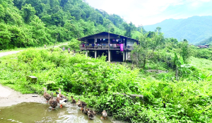
But maps, however important, cannot by themselves hold a frontier. During a recent visit to Arunachal Pradesh in the monsoon, I was struck by something far more consequential than the disputed names appearing on competing maps. Valley after valley close to the China border appeared largely uninhabited. In many remote stretches, the most visible signs of India’s presence were the personnel of the Indian Army and the Border Roads Organisation.
That stark landscape raises a difficult question: can India effectively counter China’s cartographic and territorial claims if large portions of its frontier remain without a permanent civilian population?
China’s claims go beyond changing names
China’s claim over Arunachal Pradesh is neither new nor limited to the periodic renaming of places. Beijing describes the state as 'Zangnan', or southern Tibet, and lays claim to a large part of its territory. Since 2017, it has repeatedly announced what it describes as standardised Chinese names for places in Arunachal Pradesh. Each such exercise is intended to reinforce the impression that these are Chinese territories awaiting recognition rather than Indian lands under an established system of administration.
This is not merely a linguistic exercise. Place names are instruments of territorial politics. Repeatedly naming a mountain, river, village or pass in official documents, maps and public communication creates an alternative geographical narrative.
The strategy is part of a larger Chinese approach in which maps, infrastructure, settlements and administrative structures work together. The objective is to establish a sustained presence and make territorial claims appear increasingly normal and irreversible.
India’s response, therefore, cannot stop at rejecting Chinese names.
The memory of 1962 remains powerful
The new Indian map’s emphasis on locations associated with the 1962 war carries particular significance. Longju, Thag La and other places in the eastern Himalayas are not simply dots on a military map. They are reminders of a conflict that shaped India’s understanding of its northern and eastern frontiers.
The 1962 war remains one of the defining moments in the history of independent India. Indian forces fought under extraordinarily difficult circumstances in Arunachal’s unforgiving terrain. Memorials such as Jaswant Garh have since become symbols of that resistance and sacrifice.
The significance of recalling 1962 today is not to reopen an old conflict, but to underline a historical reality: India’s relationship with this frontier did not begin with the latest roads, military posts or cartographic exercises. The region has been administered as part of India for decades, and its people have their own distinct histories, cultures and connections to the land. The memory of the war also demonstrates why the frontier cannot be viewed purely through the lens of military deployment. Empty valley is a serious strategic concern
This is where India’s border policy faces its most difficult test. The Indian Army can guard a remote post. The BRO can carve a road through mountains. New bridges and tunnels can reduce distances that once took days to cover. But neither soldiers nor infrastructure can substitute permanently for communities.
An inhabited frontier is a lived assertion of sovereignty.
The government has recognised this through initiatives such as the Vibrant Villages Programme, aimed at improving connectivity, housing, electricity, communications, education, healthcare and livelihood opportunities in settlements along the border. Such programmes are strategically important because the future of the frontier depends as much on whether families choose to remain there as on whether soldiers are deployed there. Yet development cannot mean merely constructing roads to villages that people eventually leave.
Security must include livelihoods
The communities of Arunachal Pradesh have lived with the mountains, forests and rivers of the frontier for generations. Their knowledge of the terrain is itself a strategic asset. Their presence provides a human network that no military installation can replicate. If young people are compelled to leave because there are no schools, healthcare facilities, employment opportunities or reliable communications, the resulting depopulation weakens the frontier in ways that may not be immediately visible. China understands the importance of population and infrastructure in border regions. Its approach has increasingly combined roads, settlements, administrative structures and military infrastructure. India must therefore think of border security in broader terms. A schoolteacher in a remote village, a health worker, a shopkeeper, a farmer, a tourism entrepreneur or a young family building a home near the frontier can contribute to national security in ways that rarely appear in defence statistics.
The strongest map is a living frontier
India is right to respond to China’s cartographic assertions. Naming its own places, documenting its history and marking the locations where Indian soldiers fought and died are important acts of national assertion. But the ultimate contest will not be decided by whose map contains more names. It will be decided by whose presence on the ground is stronger, more permanent and more deeply rooted. When I travelled through Arunachal’s frontier areas during the monsoon, the empty valleys left a stronger impression than any disputed map. The Army was there. The BRO was there. But in several places, ordinary civilian life seemed conspicuously absent. That should concern policymakers. China may continue to manufacture names for Indian places. India can - and should - answer with its own maps, history and administrative records.
But the most convincing response to any territorial claim is a thriving village, a functioning school, a working road, a local economy and families that have no reason to leave.
Maps can define a frontier. Soldiers can defend it. Roads can connect it. But ultimately, it is people who make a frontier truly belong to a nation.
India is right to respond to China’s cartographic assertions. Naming its own places, documenting its history and marking the locations where Indian soldiers fought and died are important acts of national assertion.
The writer is Deputy Director, Assam Information Centre, New Delhi; Views presented are personal.