
From Kedarnath to Nepal: Time to build a safer Himalaya
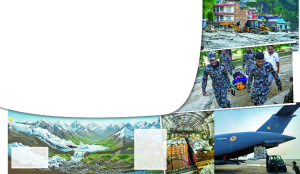
The flash floods in Nepal are a grim reminder of the unforgiving power of nature. The recurring devastation raises a larger question: are natural disasters becoming more destructive, or are these disasters are our own making? In the fragile Himalayan landscape, rapid urbanisation, unplanned construction, and a changing climate converge, can quickly turn into a disaster. The Himalayas are sending a warning, but are we listening?
Nepal's disaster on August 26, and India's own history at Kedarnath, point to the same lesson: an extreme event in the Himalaya may be unavoidable, but catastrophe is not. What decides the outcome is risk-informed planning, timely action, and treating the Himalaya as one connected system rather than separate states and borders. Nepal's floods made that brutally clear - villages erased, bridges gone, valleys cut off.
Nepal's task now is rescue and rebuilding. For India and the Himalaya, the harder question is what can be done beforehand so it doesn't become a full disaster. India has faced this before: Kedarnath in 2013, the Rishiganga-Dhauliganga flood in 2021, and Sikkim's South Lhonak glacial lake outburst in 2023 all show how these disasters cascade rather than stay contained.
The National Institute of Disaster Management studied Uttarakhand closely, recommending changes to land use, infrastructure, early warning, tourism and rebuilding. India has since improved scientific monitoring, GLOF preparedness and multi-hazard warning. A national review on September 3, led by Union Home Secretary Govind Mohan, stressed converting prediction into prevention and evacuation. Nepal shows the remaining gap: scientific capability must become operational capability.
When Hazard Triggers the Next
Nepal's floods were no ordinary flooding event. The Himalayan hazard environment is layered: rainfall, cloudbursts, landslides, avalanches, glacier retreat, glacial lake outbursts, earthquakes and slope failure all interact. A landslide can dam a river into a makeshift reservoir; a rockfall into a lake can send a wave downstream; heavy rain can loosen an unstable slope. One hazard can trigger the next faster than any warning can travel.
This is why the Himalaya must be treated as a network of river basins, not administrative territories. Nepal's surge moved through the Bhote Koshi and Trishuli basins, destroying bridges and roads, and raised river levels in India's border districts. A village that looks stable on its hillside can still be at risk from something happening kilometres upstream.
Capacity Exists - The Missing Piece Is Connecting It
India has not stood still since Kedarnath, advancing landslide forecasting, GLOF preparedness, flood modelling and multi-hazard early warning. The National Programme for Glacial Lake Outburst Flood Risk Mitigation now covers Arunachal Pradesh, Himachal Pradesh, Sikkim and Uttarakhand, with satellite, geological and meteorological data increasingly combined.
Nepal exposes the next problem. A satellite flags a dangerous lake, a model predicts extreme rain, a sensor detects rising water - then what? Who gets that information, and who orders the evacuation? The task is building the machinery that turns warnings into evacuations and road closures - that should be the real focus of Himalayan disaster management.
From Warning to Action
Surveys count roughly 7,500 glacial lakes across the Himalaya - a tenth in Sikkim, 25 rated very high risk - with nearly 4,700 in the Ganga basin alone, spanning a catchment of 2.5 lakh square kilometres. Many sit above hydropower projects, highways, border posts and populated valleys, demanding a risk hierarchy.
Every high-risk lake needs a mapped downstream footprint - villages, roads, bridges, power projects - paired with a working chain of detection, decision, warning, evacuation and verification, plus local authority to act and pre-identified shelters. Mapping vulnerable communities and rehearsing evacuation before the monsoon is a good start. Monitoring itself needs redundancy, since a hazard can destroy the instruments meant to detect it. The goal is moving from early warning to early action.
Build for the Mountains
India needs roads, tunnels, hydropower, transmission lines and tourist infrastructure in the Himalaya - mountain communities can't be isolated for conservation's sake. The question isn't whether to build, but how much, where, and to what standard. A plains-style road can't simply transfer to a mountainside: overcutting, blasting and poor drainage add to instability, and such roads often cause the landslides that block evacuation.
Himalayan disaster management.
From Early Warning to Early Action
As per the survey of the Himalayan range, there are as many as 7,500 glacial lakes in the Himalayas, including 10% in Sikkim with 25 being very high-risk. In this regard, the survey has revealed that 4,700 glacial lakes in the Ganga River basin, with an approximate catchment area of over 2.5 lakh sq. km. This means that the disaster potential of the breach of these glacial lakes is on a colossal scale. They are located above hydropower projects, highways, military/border posts, and populated valleys. All this shows that the issue requires a risk hierarchy.
There is a need to identify a downstream hazard footprint of all high-risk lakes with villages, roads, bridges, hydropower projects, etc.
This, in turn, must be complemented by response planning. With the most critical of lakes, it will be necessary to put into place a fully functioning process of detection, decision, warning, evacuation and verification. If the warning is given, there needs to be the local capacity to make decisions and act. There also need to be designated evacuation routes and designated shelters.
In its recent report, the Government has rightly focussed on the preparation of maps for vulnerable communities and significant installations, marking of flood lines, practicing of evacuation prior to the monsoon, and enhanced inter-agency coordination.
Finally, the monitoring system itself needs to be made redundant. It is worth remembering from the Nepal example how the actual monitoring equipment might itself be destroyed in the event of the disaster. Satellite monitoring, automated stations, river gauging stations and local observations all need to work in combination.
The goal must be to move from early warning to early action.
Build for the Mountains, Not Merely Through Them
The second lesson from Kedarnath pertains to infrastructure.
India needs roads, tunnels, hydropower plants, power transmission lines and tourist facilities in the Himalayas. Mountain populations cannot be left isolated on account of conservationist priorities. The question is not whether or not there should be infrastructure, but rather how much and where, and according to which engineering principles.
An ordinary road engineered for use on the plains cannot just be transferred to the mountains. Overcutting, uncontrolled blasting, insufficient drainage, weak retaining works could lead to enhanced instability. Roadways are themselves known to cause landslides and often fail when they are most required for evacuation.
There have been positive developments by the Government towards ensuring road safety through geotechnical assessments, LiDAR and UAV surveys, landslide hazard evaluation and InSAR-based monitoring. The next move should be to make these methods standard practice for all infrastructure development in the Himalaya.
All large roads, tunnels, bridges, hydropower facilities and townships should pass a Disaster Impact Assessment, evaluating not only environmental impacts, but also the impacts an extreme disaster could have on the facility itself, and the impacts the facility itself could have on the surrounding area.
Here is where the suggestion made by the former Union Minister, Dr Karan Singh, to create a Himalayan Authority also needs careful examination. He had advocated the need for such an authority for protection of the Himalayas and had mentioned his apprehensions regarding the infrastructure development, particularly the four-laning of roads.
Should such an authority be created, it must not be yet another bureaucratic entity but one that can bring together geological, hydrological, ecological, climate science and disaster management expertise as well as development planning experience.
Land Use Is the Best Way to Prevent Disasters
Science may alert us, but technology cannot ensure that an unsafe area becomes safe.
It is one of the main lessons learned from the Uttarakhand disaster. Risk assessments and maps of hazards must shape land use decisions. Flood plains, hazardous slopes, and debris flow channels should not become commercial areas just because they are commercially lucrative.
The question must move from "Is there enough technology for construction in the given area?" to "Should we build there?"
The lesson learned from the Kedarnath tragedy is not the ban on pilgrimage and tourism. It should include risk-based management of visitors.
The Community Needs to Become the First Responder
Whatever the level of sophistication of the warning system of the country, the first responder in any small Himalayan village is going to be the local population. Each vulnerable village should have first responders, emergency communications, an evacuation path and a place of safety marked out.
This is also the time when pre-positioning becomes key. Food, medicine, drinking water, fuel, rescue equipment and emergency communications should all be stockpiled at strategic safe locations before the roads become inaccessible.
Reconstruction Must Not Recreate the Next Disaster
The biggest challenge for Nepal will occur after the immediate crisis subsides.
Reconstruction tends to be reactive: rebuild the home, repair the road, reconstruct the bridge, open the tourism destination. But simply reconstructing what once was will simply create the next disaster.
Risk assessment is thus an essential first step for reconstruction to begin.
If the settlements are unsafe, they should be relocated where necessary. Livelihoods too have to form part of reconstruction efforts.
The principle should be "Build Back Better", not merely build back what was lost.
The Himalayas Need a Common Risk Framework
One of the greatest lessons to be drawn from the disaster in Nepal is that the disaster management approach in the Himalayas cannot be limited to national and state boundaries alone.
The sources of a particular hazard may lie in one nation; the path of a flood may pass through another, and its effects may spread hundreds of kilometres out into the plains. Thus, India and Nepal need to have an institutionalised system for the real-time exchange of information on rain, river levels, glacial lakes, landslides and other hazards. The Centre has requested all agencies to provide information in real time rather than after the start of the disaster.
But coordination needs to go beyond meetings. There has to be a common risk map of the valley which includes hazard source, expected flow path, vulnerable population and infrastructure, warning status, evacuation routes and response capabilities.
The same logic applies to the entire Himalayan range. The Himalayas require a risk-information architecture connecting government authorities, scientific institutions, infrastructure authorities and local populations.
The Real Measure of Preparedness
The problem of disaster preparedness in the Himalayas is increasingly not about knowing what to do. We have much of the knowledge, technology and institutional structures needed for preparedness.
India has come a long way since Kedarnath in terms of developing early warning systems, mitigation of GLOF risk, landslide prediction, satellite monitoring, weather observation, community response programs and a more scientific approach to infrastructure. The current high-level assessment demonstrates that the Government is increasingly seeking to develop preparedness into prevention, evacuation and last mile efforts.
What remains is to connect the pieces.
Risk maps need to influence construction. Warnings need to lead to decisions. Sensors need to prompt evacuation. Roads need to be constructed around geological realities. Tourism needs to consider carrying capacity. Critical infrastructure needs to be considered from cascading hazard perspective. Communities need to be trained before-not after-a disaster strikes.
And most importantly, the Himalayas require a development philosophy of their own.
The mountains do not oppose development. They oppose development which does not comprehend the mountains.
Nepal has paid a terrible price. India has already paid its own price at Kedarnath and in subsequent Himalayan disasters. We cannot stop extreme rainfall, avalanches, landslides or glacial lake outbursts. But we can minimize the number of people and assets that are exposed to them, ensure fast warning and evacuation measures and infrastructure which doesn't enhance their impact.
In other words, the ultimate test of disaster management is not how successfully we rescue people from the calamity. Rather, it's the number of people who did not face the calamity because of beforehand risk reduction.
The Himalayas will always be hazardous. Climate change will increase the uncertainty and intensity of the hazards. Our only choice is whether our development is still vulnerable to such dangers.
The true tribute to those lost in Nepal-and to those lost at Kedarnath-is not another report after the next disaster. It is a safer Himalaya built before it comes.
A Glacial Lake Outburst Flood
As global temperatures rise, glaciers melt and retreat. As a moving glacier shrinks, it leaves behind unstable wall consisting of loose rocks, sediment, boulder debris.
A disaster is frequently triggered by calving, where a massive chunk of the remaining glacier or an adjacent hanging ice-rock face breaks off and crashes into the lake. This sudden impact generates displacement waves. The rushing water rapidly erodes the loose sediment, causing devastating flood
Dr Satendra, IFS, Former Executive Director, National Institute of Disaster Management and Director, SAARC Disaster Management Centre; Views presented are personal.