UN votes to redraw the world: Global South to get its true size
The UN’s overwhelming backing for a more accurate map of the world may look like a cartographic correction. But behind the push to reduce Mercator’s dominance lies a larger Global South challenge to inherited ways of representing geography, power and place
“A map is not just a picture of the world; it is a picture of how we understand the world.” That idea has acquired a new significance at the United Nations, where the General Assembly has overwhelmingly backed a resolution calling for a more accurate representation of the size of the world’s continents. In a remarkable vote, 164 countries supported the resolution, the United States voted against it and six countries abstained. Led by Togo, with the backing of the African Union, the initiative seeks to correct the distortions created by the world map that generations have grown up with. Africa is set to appear much closer to its actual size, while Europe and North America will lose some of the visual prominence they acquire on the familiar Mercator projection. What appears at first to be a technical debate among cartographers has therefore become something much bigger: a statement from the Global South that the map of the world should reflect the world as it actually exists.
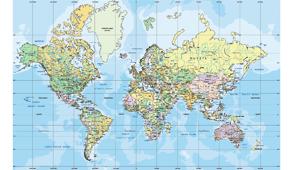
The resolution promotes the wider use of equal-area map projections, including the Equal Earth projection, developed in 2018. The purpose is not to declare one map the only correct map, nor does the resolution ban the centuries-old Mercator projection. It encourages the use of projections that preserve the relative area of continents when the purpose is to understand their actual geographical size. That distinction matters because every flat map of a spherical Earth involves some distortion. The real question is what a map chooses to preserve and what it chooses to distort. The Mercator projection preserves angles and directions, which made it exceptionally useful for navigation. Equal-area projections give priority to preserving the relative size of landmasses. In an age of satellites, GPS and digital cartography, the world no longer needs to depend on one projection for every purpose.
The Mercator map has a remarkable history. Flemish cartographer Gerardus Mercator introduced it in 1569, when European ships were venturing across oceans in search of new trade routes and territories. His objective was not to create a map that accurately compared the size of continents. It was to help sailors navigate. By preserving angles and directions, Mercator produced a revolutionary tool for maritime navigation. The map served its original purpose brilliantly. The difficulty came when a map created for sailors gradually became the most familiar visual representation of the entire planet. A navigation chart was transformed into a picture through which generations of schoolchildren came to understand the world. The distortion becomes obvious when we compare Greenland with Africa. On a conventional Mercator map, Greenland can appear almost as large as Africa. In reality, Africa is roughly 14 times larger than Greenland. The reason is mathematical. As the spherical Earth is projected onto a flat surface, areas become increasingly enlarged towards the poles. Greenland, located close to the Arctic, is therefore dramatically exaggerated, while Africa, much closer to the Equator, appears considerably smaller than its actual area. Europe and North America also acquire a greater visual size, while Africa and South America are compressed. The map is not “wrong” in the sense that Mercator failed at his original task. It becomes misleading when people use it to compare the actual geographical size of continents.
This is where the new UN initiative acquires its political and cultural significance. For the Global South, the problem is not merely that Africa looks smaller on a classroom map. Maps influence the imagination. Children encounter the world first through maps before they learn about population, resources, economic power or political influence. What appears large can unconsciously appear important; what appears small can seem peripheral. A cartographic distortion can therefore become a distortion of perception. The African argument is that a continent whose geographical reality is immense should not continue to be visually diminished simply because a sixteenth-century navigation system became the standard image of the world.
Togo’s initiative, supported by the African Union, reflects a broader effort to challenge inherited systems of representation. The resolution highlights the educational, cultural, political, social and economic consequences of distorted maps. The underlying argument is powerful: geographical representation is not politically neutral when the same visual distortion is repeated for generations.
The history of cartography demonstrates the relationship between maps and power. Empires mapped territories they controlled, colonial administrations mapped borders and resources, and governments used maps to define political space. Yet the Mercator projection was created primarily for navigation, and its technical value remains undeniable. The important point is that the world has changed while the visual convention has remained remarkably persistent. The Equal Earth projection offers a different approach, preserving the relative areas of continents more accurately. Africa appears larger, South America gains its geographical weight and Asia’s enormous scale becomes more apparent. No flat map can eliminate distortion, but Equal Earth is better suited to comparing continental size.
India’s support for the resolution reflects this wider Global South context. New Delhi has backed greater cartographic accuracy while emphasising that different maps serve different purposes. The principle is not simply to replace Mercator with Equal Earth, but to use the projection most appropriate to the purpose.
The United States, the only country to vote against the resolution, criticised the initiative as unnecessary while the world faces wars, economic crises, climate change and migration. But if maps are among the first tools through which people learn about the world, representation matters. It shapes perception and how people understand their place in the world.
The UN resolution therefore should not be interpreted as the death of the Mercator projection. It is better understood as a challenge to its universal dominance. Mercator will remain useful for specific navigational purposes. The resolution asks governments, educational institutions and international organisations to give greater consideration to equal-area projections when geographical size is the subject being represented. That is a modest technical change on paper, but it carries a larger symbolic message. The world of the twenty-first century is no longer the world of sixteenth-century sailing ships. Satellites can photograph the Earth, computers can model it in three dimensions and digital platforms can switch between projections instantly. There is little reason to pretend that one centuries-old projection must serve every modern purpose.
The real significance of the vote lies in the fact that the Global South is increasingly questioning not only the distribution of economic and political power, but also the systems through which knowledge about the world has been produced and communicated. Africa is not becoming larger because of this resolution. Europe is not becoming smaller. The geographical facts have never changed. What is changing is the representation of those facts. The new map simply asks people to see Africa as large as Africa really is, South America as large as South America really is and Asia in proportion to its enormous geographical reality.
The debate also offers a lesson in humility. There is no perfect world map. Every projection involves choices. The important thing is to recognise those choices instead of treating a particular map as an unquestionable picture of reality. The Mercator projection was a masterpiece for navigation. Equal Earth is better suited to showing relative land area. Other projections will remain useful for climate studies, aviation, regional mapping and many other purposes. The future of cartography should therefore be plural rather than uniform, accurate rather than inherited. For the Global South, this is ultimately about more than cartography.
It is about visibility and correcting a visual imbalance repeated so often that it came to look natural. The UN vote gives that argument an international platform. A map cannot redistribute power, but it can change how people understand it. “If the picture of the world is distorted, our understanding of the world will be distorted too.” That is the larger message behind this seemingly unusual UN resolution. The Earth has not changed since Mercator drew his map nearly five centuries ago. Our technology has changed, our geopolitics has changed and the Global South’s voice has grown louder. Now the cartographic picture is being asked to catch up with reality. The world is not being redrawn; the way we see the world is.
“If the picture of the world is distorted, our understanding of the world will be distorted too.” That is the larger message behind this seemingly unusual UN resolution. The Earth has not changed since Mercator drew his map nearly five centuries ago. Our technology has changed, our geopolitics has changed and the Global South’s voice has grown louder
The writer is Professor at Centre for South Asian Studies, School of International Studies & Social Sciences Pondicherry Central University; Views presented are personal.