
1807 British map reveals Capital’s old names and forgotten landscape
Mapping a territory is perhaps one of the foremost ways of establishing dominion over it. Thus, when the British East India Company occupied this city after defeating the Marathas in the Battle of Delhi in 1803, one of the first things they did was to map its localities.
More than a century before the popular landmarks and grand avenues of the imperial capital came into being, Mehrauli was ‘Mouralee ‘, Indraprastha ‘Indiput ‘, the Yamuna was ‘Jumnah ‘ and Okhla ‘Okilluh’ to the British surveyors who put Delhi on paper for the first time — some four years after establishing dominion over the city.
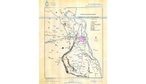
The 1807 map captures a Delhi that feels familiar, and yet almost unrecognisable: the walled city of Shahjahanabad, the Yamuna flowing along the ramparts of the Red Fort, villages scattered across fields, streams descending from the Ridge, ‘sarais ‘ (residences) lining bustling trade routes and a landscape of monuments, orchards and open countryside stretching far beyond.
‘Sketch of the Environs of Delhi’, a hand-drawn map attributed to British surveyor F S White, is one of the earliest maps of the capital in Survey of India’s archives. It captures familiar locales that survive to this day, separated by open landscape stretching far and wide.
Shahjahanabad sits at the heart of the city, its built-up expanse shaded pink, with its gates and major structures marked in detail.
The Red Fort is identified simply as ‘The Palace’, while Salimgarh appears as ‘Juleemgurh’ and the Jama Masjid as ‘Jumma Musjhid’. Around the walls are Dillee Gate (Delhi Gate), Ajmeer Gate (Ajmeri Gate), Lahor Gate (Lahori Gate), Kabul Gate (Khooni Darwaza), and Toorkman Gate (Turkman Gate). Beyond the walled city, the dense cluster of buildings gives way to villages, roads, sarais, and scattered historic sites.
The quaint spellings of place names offer a glimpse into how British surveyors perceived regional languages and dialects as they navigated a city they had come to occupy recently.
Rithala became ‘Rittaluh ‘, Sarai Juliana appears as ‘Injuleh Sarai’, Moti Bagh as ‘Mochee Bagh’, and Tihar as ‘Teehar’ — spellings that can seem whimsical today but were often attempts to reproduce names as they sounded to the surveyors.
While the map has changed, many of these names have stuck to this day. Rittaluh (Rithala), Badlee (Badli), Jusroulah (Jasola), Okilluh (Okhla) and Kulkajhee (Kalkaji) remain landmarks in the modern city.
What has changed is the landscape around them.
To the north and northwest of Shahjahanabad, the map places familiar settlements amid far more open landscapes than the one surrounding them today. Rithala and Badli appear as villages, while Wuzeerabad (Wazirabad) lies by the Yamuna.
Puhargunj, today’s Paharganj, sits outside the walled city. The Western Yamuna Canal cuts across the landscape, while routes marked on the map connect these settlements to Shahjahanabad and to the larger network of roads leading out of Delhi.
South of Shahjahanabad, the map begins to connect the old city with monuments, villages, and roadside settlements that would eventually be swallowed up by the expanding capital. Feroz Shah’s Palace, now Feroz Shah Kotla, is marked prominently, while Indiput appears near the Purana Qila.
The name ‘Indiput’ is particularly intriguing because Indraprastha has older linguistic parallels, including the Pali name ‘Indapatta.’
Further south are Beegampor, or Begampur, and Sieud Lujab, now Said-ul-Ajaib. Mooralee is Mehrauli, then a small settlement in an expansive open landscape, leads towards Kanhpor further south, Khanpur of today.
The old roads south of Delhi are dotted with sarais along them — Shekh Seraee, Toot Saraee, Keem Seraee, Jeer, and Beer Seraee. These were resting stops for travellers and traders moving along these routes in and out of the city.
Other names point to landscapes that have proved less durable. Khierpor, a village near Sufterjung’s Tomb (Safdarjung Tomb) stood in the area that is now Lodhi Gardens.
The Yamuna itself is ‘Jumnah’, running close to Shahjahanabad and the Red Fort, while the eastern bank remained sparsely populated.
The map, therefore, is not simply a depiction of a city. It captures its various indices — the walled Mughal city and stray settlements, roadways and waterways, agrarian lands and bustling trade routes, and its languages and cultures — as the colonial surveyor tries to make sense of it all.